Wholesale 66 channel logger M1200E
批发66通道记录仪M1200E
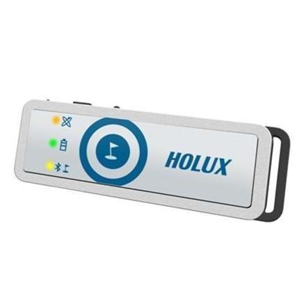
HOLUX M-1200E蓝牙充电式USB GPS记录器 超小型GPS记录器仅重32克,适用于携带与你在任何时候 高灵敏度GPS接收具有高达2.5M准确性 66并行通道,以便快速的GPS定位 GPS,电池和蓝牙状态通过3个LED 利益按钮单按点 可以作为无线蓝牙GPS接收器或USB GPS接收机不会搭配手机,手提电脑 与第三方移动GPS导航软件(不含税)WORKS 附带的软件可以详细的路线分析 符合出口到Google Earth和其他流行的绘图软件 软件支持照片地理标记及简单的上传到照片共享网站 产品详情 超小巧轻便的USB GPS数据记录仪具有高灵敏度的MTK 3329 GPS芯片组。 在M-1200E达到3米精度,无需援助从而提高了2.5米精度DGPS。 在M-1200E GPS记录器有一个通断开关,一旦被开启后就会立即使用66并行通道来搜索GPS定位。 它实现了在短短的一秒钟热启动修复,并且只需要36秒一个完全冷启动。 在M-1200E GPS记录器有3个LED指示灯和感兴趣的记录点一个按钮: 卫星LED - 纯橙色寻找GPS定位时,闪烁橙色当修复完成 电池指示灯 - 在正常使用过程绿色充电,关闭时,红当电池电量低 蓝牙指示灯 - 当POI按下按钮时蓝牙传输变为黄色闪烁蓝灯 大的4兆字节存储器允许多达200000航点被记录,与各自含有的位置,速度和高度。 在M-1200E GPS记录器可以通过附带的软件配置在步行上班,跑步,骑自行车或车辆模式。 每个模式可以被设置为用户指定的时间或距离的自动记录的航点。 该记录器有一个内置的可充电锂离子电池,可以通过USB端口或通过电源充电器(另售)进行充电。 通过与移动电话或PDA它可以作为一个无线蓝牙GPS接收器提供的第三方GPS导航软件数据配对的M-1200E单元(不包括在内)。 这也可以通过记录仪连接到移动或笔记本电脑附带的USB电缆来实现的。 捆绑长天ezTour软件允许行程数据从记录仪中读取。 使用EZTour的最新版本记录软件 - 2.01版及以上 - 路线可以显示在谷歌地图和数据可以询问在细节和绘制成图。 数据可以进行编辑,导出到谷歌地球或另存为。 GPX文件导入到支持。GPX格式的其他软件。 HOLUX ezTour让照片文件进行自动地理标记通过同步记录时间在相机中设置的时间。 该位置将被写入到照片文件和ezTour使得简单的将它们上传到照片共享网站,如Flickr和LOCR它。 软件兼容性 请注意,长天ezTour软件只能在Windows XP,Vista和Windows 7兼容。 该软件和设备已经被彻底每种操作系统进行测试。 因为人多,可能的PC配置,我们很遗憾,我们无法提供单独的驱动程序,软件或连接问题的支持。 框的内容 M-1200E GPS接收器 尼龙带 USB充电线 车载充电器 快速入门指南 技术规格 MTK 3329 GPS芯片 L1为1575.42MHz 高灵敏度-165dBm 66并行通道,可快速定位 1秒的热启动,33秒预热启动,36秒冷启动 内置WAAS / EGNOS / MSAS解调器 3米精度,无需援助和2.5米精度DGPS 4MB闪存,可以存储200000航点 WGS84数据 550MAH锂离子充电电池 长达13小时前充电可连续使用 USB 2.0全速通过mini-USB连接兼容接口 蓝牙无线传输与蓝牙串行端口配置文件完全兼容 -10 - 45°C的工作温度 -20至60摄氏度储存温度 用户可升级固件 68.5 x 22.8 x15.5毫米 约32克重量 1年制造商的保修 |
HOLUX M-1200E BLUETOOTH RECHARGEABLE USB GPS LOGGER ULTRA-COMPACT GPS LOGGER WEIGHING JUST 32 GRAMS, IDEAL FOR CARRYING WITH YOU AT ALL TIMES HIGH SENSITIVITY GPS RECEIVER ACHIEVES UP TO 2.5M ACCURACY 66 PARALLEL CHANNELS FOR QUICK GPS FIX GPS, BATTERY AND BLUETOOTH STATUS VIA 3 LEDS SINGLE PRESS POINT OF INTEREST BUTTON CAN WORK AS A WIRELESS BLUETOOTH GPS RECEIVER OR USB GPS RECEIVER WHEN PAIRED WITH A MOBILE OR LAPTOP WORKS WITH 3RD PARTY MOBILE GPS NAVIGATION SOFTWARE (NOT INCLUDED) INCLUDED SOFTWARE ALLOWS DETAILED ROUTE ANALYSIS WITH EXPORT TO GOOGLE EARTH AND OTHER POPULAR MAPPING SOFTWARE SOFTWARE SUPPORTS PHOTO GEOTAGGING AND SIMPLE UPLOAD TO PHOTO SHARING WEBSITES PRODUCT DETAILS Ultra-compact and lightweight USB GPS data logger with high sensitivity MTK 3329 GPS chipset. The M-1200E achieves 3m accuracy without aid which improves to 2.5m accuracy with DGPS. The M-1200E GPS logger has an on-off switch and upon being turned on will immediately use 66 parallel channels to search for a GPS fix. It achieves a fix in just one second for a hot start, and only takes 36 seconds for a completely cold start. The M-1200E GPS logger has 3 LEDs and a button for recording points of interest: Satellite LED - Solid orange when searching for a GPS fix, blinking orange when fix achieved Battery LED - Green when charging, off during normal use, red when battery is low Bluetooth LED - Flashes blue during Bluetooth transmission changes to yellow when POI button pressed The large 4 megabyte memory allows up to 200000 waypoints to be recorded, with each containing position, speed and altitude. The M-1200E GPS logger can be configured via the included software to work in walking, running, cycling or vehicle modes. Each mode can be set to record waypoints automatically by a user specified time or distance. The logger has a built-in rechargeable lithium-ion battery, which can be charged from a USB port or via a mains charger (available separately) . By pairing the M-1200E unit with a mobile phone or PDA it can act as a wireless Bluetooth GPS receiver providing data for third party GPS navigation software (not included) . This can also be achieved by connecting the logger to the mobile or laptop with the supplied USB cable. The bundled Holux ezTour software allows trip data to be read from the logger. Using the latest version of the EZTour for Logger software - Version 2.01 and above - routes can be shown on a Google Map and the data can be interrogated in detail and plotted as graphs. Data can be edited, exported to Google Earth or saved as . gpx files for importing into other software that supports the .gpx format. Holux ezTour allows photograph files to be automatically geo-tagged by synchronising the logger time with the time set in the camera. The position will be written to the photo files and ezTour makes it simple to upload them to photo sharing sites such as Flickr and Locr. SOFTWARE COMPATIBILITY Please note the Holux ezTour software is only compatible with Windows XP, Vista and Windows 7. The software and device have been thoroughly tested with each of these operating systems. Because of the multitude of possible PC configurations we regret that we are unable to provide support for individual driver, software or connectivity problems. BOX CONTENTS M-1200E GPS Receiver Velcro strap USB charging cable Car charger Quick start guide TECHNICAL SPECIFICATION MTK 3329 GPS chip L1 1575.42MHz High sensitivity to -165dBm 66 parallel channels for fast acquisition 1 sec hot start, 33 sec warm start, 36 sec cold start Built in WAAS/ EGNOS/ MSAS demodulator 3m accuracy without aid and 2.5m accuracy with DGPS 4MB flash memory which can store up to 200000 waypoints WGS84 datum 550mAh rechargeable lithium-ion battery Up to 13 hours continuous use before recharge USB 2.0 full speed compliant interface via mini-USB connector Bluetooth wireless transmission fully compatible with Bluetooth Serial Port Profile -10 - 45 degrees C operating temperature -20 to 60 degrees C storage temperature User upgradeable firmware 68.5 x 22.8 x 15.5 mm Approx 32 grams weight 1 year manufacturer's warranty |

&img=www.atupapa.com/show/wxbuyer/img/apk.png&url=//www.atupapa.com/show/wxbuyer/whatnear.apk)