- Marketplace
- Merchants
- Restaurants
- UAE house
- Cloud accounting (GCC VAT)
- Me
- Cart
- My order
- Address book
- Favorite
- Link
- About us
- Download App
- 中文
- Merchant panel
LMJ-I authentic path area measurement instrument withour rangefinder GPS area measuring instrument measuring instrument
LMJ-I authentic path area measurement instrument withour rangefinder GPS area measuring instrument measuring instrument
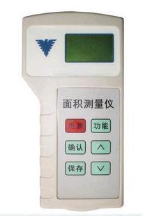
Product parameters:
- Customized processing: no
- Brand: path
- Model: LMJ-I area measurement instrument
LMJ-I area measurement instrument (Acre measurement instrument)
| ||
Used GPS positioning system, embedded single tablets machine, high precision algorithm, advanced technology development and into of field area measurement instrument, can fast mapping any shape plots of area, distance, perimeter, data, applies Yu farmland, green, forest, waters, beach, factories, area of measurement, for agricultural, forestry, water, soil tube, tax, sector and the farm machinery job charges, provides convenient of measurement tool. Automatically calculate the average of several measurements data, General requirements for measuring actual measurement twice to improve measurement accuracy. Through satellite positioning real-time displays the latitude and longitude of the location, easy to pinpoint. By measuring coordinates of two points, quickly calculates the distance between two points, in meters shown. Area measurement, if the end point and the starting point does not coincide, the instrument is filled with lines of these two data and calculating area. |
Technology Operation To point to Mark | 1. measurement data: area; Distance; The perimeter; Longitude and latitude; Time; Price 2. measuring range: 300-9999999 square meters, or 0.5-999999.9 Acres; Accuracy: 0.1 acres (﹤ 3) or 3% (﹥ 3 acres) 3. distance measurement range: 10-999999.9 m; Accuracy: 2 meters 4. time accuracy: ﹤ 0.5 seconds 5. the unit settings: 0.5 to 999.5 Yuan/Mu 6. record stores: 128, power-off protection 7. power supply: 4 5th, alkaline batteries 8. the instrument size: 156mmx80mmx25mm |

&img=www.atupapa.com/show/wxbuyer/img/apk.png&url=//www.atupapa.com/show/wxbuyer/whatnear.apk)